-
Tips for becoming a good boxer - November 6, 2020
-
7 expert tips for making your hens night a memorable one - November 6, 2020
-
5 reasons to host your Christmas party on a cruise boat - November 6, 2020
-
What to do when you’re charged with a crime - November 6, 2020
-
Should you get one or multiple dogs? Here’s all you need to know - November 3, 2020
-
A Guide: How to Build Your Very Own Magic Mirror - February 14, 2019
-
Our Top Inspirational Baseball Stars - November 24, 2018
-
Five Tech Tools That Will Help You Turn Your Blog into a Business - November 24, 2018
-
How to Indulge on Vacation without Expanding Your Waist - November 9, 2018
-
5 Strategies for Businesses to Appeal to Today’s Increasingly Mobile-Crazed Customers - November 9, 2018
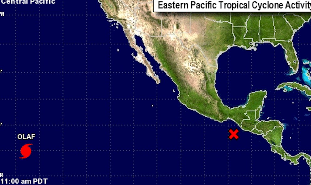
Hurricane Olaf Projected Path Updated by National Hurricane Center
Olaf is the 6th major hurricane in the eastern North Pacific this year. Once Olaf crosses over 140ºW longitude, possibly on Tuesday, tracking will be handed over to the Central Pacific Hurricane Center.
Advertisement
Olaf is expected to continue on the west path today and could possibly reach a Category 4 storm status. A turn toward the west-northwest is expected Monday night, continuing through Wednesday.
As of 5 a.m., Hurricane Olaf was about 1,345 miles east-southeast of Hilo, traveling at a rate of about 14 mph in a west direction.
The storm’s maximum sustained winds early Monday are near 100 miles per hour (155 kph). Hurricane force winds extend outward up to 25 miles (35 km) from the center and tropical storm force winds extend outward up to 140 miles (220 km), though are not impacting any land masses.
Although there are now no coastal watches or warnings in effect, on its projected path the outer bands of Hurricane Olaf are likely to brush the Hawaii islands.
Advertisement
Hurricane Olaf is expected to cross over into the Central Pacific Hurricane Center’s area of responsibility Monday night. There is reasonably good agreement among models regarding the forecast track. For now Olaf is Category 3.


