-
Tips for becoming a good boxer - November 6, 2020
-
7 expert tips for making your hens night a memorable one - November 6, 2020
-
5 reasons to host your Christmas party on a cruise boat - November 6, 2020
-
What to do when you’re charged with a crime - November 6, 2020
-
Should you get one or multiple dogs? Here’s all you need to know - November 3, 2020
-
A Guide: How to Build Your Very Own Magic Mirror - February 14, 2019
-
Our Top Inspirational Baseball Stars - November 24, 2018
-
Five Tech Tools That Will Help You Turn Your Blog into a Business - November 24, 2018
-
How to Indulge on Vacation without Expanding Your Waist - November 9, 2018
-
5 Strategies for Businesses to Appeal to Today’s Increasingly Mobile-Crazed Customers - November 9, 2018
Toyota to unveil a new map generation system at CES
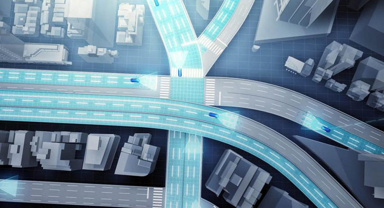
Toyota announced Tuesday that it will unveil a new system of “high-precision” mapping at the Consumer Electronic Show next month.
Advertisement
The information will then be sent to data centres that automatically update and generate high-precision road maps that cover a wide area.
Conventional road data gathering relies on specially-built vehicles with three-dimensional laser scanners.
Toyota’s system will try to gain a better understanding of actual road layouts and traffic rules, including speed limits and road signs. Also, it says that “precise measurement of vehicle positional data requires the collection of information on dividing lines, kerbs and other road features”. Toyota would be using a whole fleet of map generators on the roads, the auto maker believes that the power of having many cars out there on the roads, will make up for the lack equipment that Google and Apple use for their maps.
Toyota says that traditional mapping, as used by most sat-navs and GPS systems is of limited use due to the “infrequent” nature of the data-collection method – essentially, the maps aren’t updated often enough. We’ve already learnt that the Ford GT will be the Official Vehicle of CES 2016, and now we can also reveal what to expect from Japanese automaker Toyota at the show.
Toyota stated “the system’s margin error [is limited] to a maximum of 5 cm on straight roads”, in a press release and that the tech would be phased in for highway use only but eventually ramped up to, well, everywhere.
Initially the company is planning to use the system in expressways, and it plans to develop its functionality to cover ordinary roads and assist in hazard avoidance. Toyota plans to work with mapmakers to improve both its and their maps in a bid to improve services offered to both private and public sectors. A vehicle’s integrated cameras and Global Positioning System sensors collect road images and location information on the fly.
The company’s system will be included in automated driving vehicles that will be available for purchase by the year 2020. This way they can warn other drivers of potholes and to avoid them.
Advertisement
Toyota’s high-precision mapping will use production cars to create a realtime digital map of roadways.


