-
Tips for becoming a good boxer - November 6, 2020
-
7 expert tips for making your hens night a memorable one - November 6, 2020
-
5 reasons to host your Christmas party on a cruise boat - November 6, 2020
-
What to do when you’re charged with a crime - November 6, 2020
-
Should you get one or multiple dogs? Here’s all you need to know - November 3, 2020
-
A Guide: How to Build Your Very Own Magic Mirror - February 14, 2019
-
Our Top Inspirational Baseball Stars - November 24, 2018
-
Five Tech Tools That Will Help You Turn Your Blog into a Business - November 24, 2018
-
How to Indulge on Vacation without Expanding Your Waist - November 9, 2018
-
5 Strategies for Businesses to Appeal to Today’s Increasingly Mobile-Crazed Customers - November 9, 2018
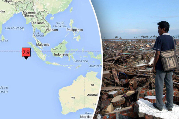
Indonesia, Australia issue tsunami warning after Massive Earthquake off Sumatra
The U.S. Geological Service said the natural disaster, which struck Wednesday evening, had a preliminary magnitude of 7.9.
Advertisement
The epicentre was 502 miles (808km) south-west of Padang, USGS said. Australia’s Bureau of Meteorology has also issued tsunami warning for its western coast, including for the city of Perth, and asked people to stay away from waterfronts.
The shallower a quake, the more likely it is to cause damage.
It was six miles deep.
Tsunami alerts are issued for five provinces of West Sumatra, North Sumatra, Aceh, Bengkulu and Lampung, BNPB spokesman Sutopo Purwo Nugroho said.
The quake was centered in the Indian Ocean about 410 miles (660 kilometers) southwest of Muara Siberut and roughly 500 miles west-southwest of Padang, which is on the west coast of Sumatra, the Asian archipelago nation’s largest island.
“We keep on observing the height of wave”, local television reported Andi Eka Sakya saying.
Erwin, a resident of Mentawai, a chain of islands off Sumatra, told Metro TV: “I am at the beach now looking to see any tsunami sign with my flashlight”.
Traffic ground to a halt and there was a sense of panic on the streets, the journalist said. USGS originally put the magnitude at 8.2, and then 8.1, before lowering it to 7.9.
Indonesia lies within the Pacific’s “Ring of Fire”, where tectonic plates collide and cause frequent seismic and volcanic activity.
A monster quake off Indonesia in 2004 triggered a tsunami that killed 230,000 people in a dozen countries.
Advertisement
Indonesia, especially Aceh, was badly hit by the Indian Ocean tsunami in 2004.


