-
Tips for becoming a good boxer - November 6, 2020
-
7 expert tips for making your hens night a memorable one - November 6, 2020
-
5 reasons to host your Christmas party on a cruise boat - November 6, 2020
-
What to do when you’re charged with a crime - November 6, 2020
-
Should you get one or multiple dogs? Here’s all you need to know - November 3, 2020
-
A Guide: How to Build Your Very Own Magic Mirror - February 14, 2019
-
Our Top Inspirational Baseball Stars - November 24, 2018
-
Five Tech Tools That Will Help You Turn Your Blog into a Business - November 24, 2018
-
How to Indulge on Vacation without Expanding Your Waist - November 9, 2018
-
5 Strategies for Businesses to Appeal to Today’s Increasingly Mobile-Crazed Customers - November 9, 2018
Fate of cargo ship caught in Hurricane Joaquin unknown
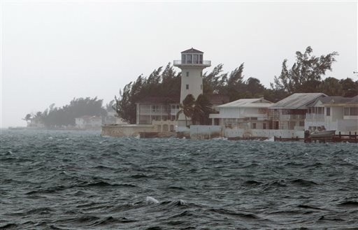
Hurricane Joaquin, packing fierce winds and driving rain, is bearing down on the Bahamas as the US East Coast breathes a tentative sigh of relief amid forecasts the storm is set to stay out to sea.
Advertisement
Rescue workers searched for a missing cargo ship with 33 aboard off the Bahamas on Friday (Oct 2) as Hurricane Joaquin tore through the island chain, halting life in the popular tourist destination.
The crew of the U.S.-flagged ship-28 USA citizens and five Polish nationals-told officials that its engine was disabled, and it was taking on water and listing to the side at an angle of 15 degrees.
Power also was knocked out to several islands, and Leslie Miller, executive chair of the Bahamas Electricity Corporation, said the company “is in no position to do much” to restore electricity. Two Air Force Hurricane Hunter crews failed to find the ship earlier.
“The forecast models continue to indicate a track farther away from the United States east coast and the threat of direct impacts from Joaquin in the Carolinas and mid-Atlantic states appears to be decreasing” rhe NHC said.
The storm’s “extremely risky conditions” are expected to continue over portions of the Bahamas on Friday, according to the National Hurricane Center.
There will be an area of intense rain, mostly likely around North Carolina, from Joaquin but we may skate by with just some big waves and a few showers.
“The great news for us is that we will have dodged a bullet”, Suffolk County Executive Steve Bellone said at a news conference late Friday morning at Robert Moses State Park.
As reported in Tribune 242, Captain Stephen Russell of the National Emergency Management Agency (NEMA) said that residents in the area did not want to leave their homes and were refusing to go to the shelters.
Joaquin is the third hurricane of the 2015 Atlantic season, which began in June and ends in November.
“The storm is so bad and slow moving it’s hard for our planes to get low enough to inspect the surface of the water”.
The National Hurricane Center in Miami said late Thursday that Joaquin was centered about 20 miles (35 kms) southeast of Clarence Town, Long Island, Bahamas, and about 75 miles (120 kms) south of San Salvador, Bahamas. When it did, the ship’s officers were monitoring what was then Tropical Storm Joaquin, according to Tim Nolan, president of TOTE Maritime Puerto Rico, which owns the vessel. Bermuda has issued a tropical storm watch.
Advertisement
Authorities in the nearby Turks & Caicos Islands closed all airports, schools and government offices. In Cape May, N.J., for example, storm surge is now approaching three feet-higher than the level recorded during Hurricane Irene’s landfall in 2011.


