-
Tips for becoming a good boxer - November 6, 2020
-
7 expert tips for making your hens night a memorable one - November 6, 2020
-
5 reasons to host your Christmas party on a cruise boat - November 6, 2020
-
What to do when you’re charged with a crime - November 6, 2020
-
Should you get one or multiple dogs? Here’s all you need to know - November 3, 2020
-
A Guide: How to Build Your Very Own Magic Mirror - February 14, 2019
-
Our Top Inspirational Baseball Stars - November 24, 2018
-
Five Tech Tools That Will Help You Turn Your Blog into a Business - November 24, 2018
-
How to Indulge on Vacation without Expanding Your Waist - November 9, 2018
-
5 Strategies for Businesses to Appeal to Today’s Increasingly Mobile-Crazed Customers - November 9, 2018
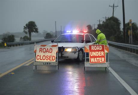
Hurricane Hermine Floods Coastal Areas, Downs Trees As It Hits Florida
Hermine has the potential to become a Category 1 hurricane by the time it’s expected to make landfall Thursday night into Friday morning near Apalachicola.
Advertisement
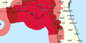
A hurricane warning was in effect on Florida’s Gulf Coast from the Suwannee River to Mexico Beach as well as inland areas including Tallahassee.
A tropical storm warning is in effect for Charleston, Berkeley, Dorchester and Colleton counties as Hermine gains strength.
Forecasters warned Hermine could pack wind gusts topping 80mph with storm surge reaching 7 feet. Along with high winds, a deluge of 10-15 inches of rain are expected in some areas; flooding and tornados are also a worry.
Its maximum sustained winds strengthened to 65 miles per hour, nearing the minimum 74 miles per hour of a category one hurricane.
Conditions deteriorated as Hermine, a Category 1 hurricane packing winds of 80 miles per hour (130 km/h), made landfall with several areas in Florida already reporting 5 inches (12 cm) of rain as more than 70,000 households in Tallahassee and thousands more along the coast were without power.
The state of Florida declared mandatory evacuations in the counties of Dixie, Franklin, Taylor, Wakulla and Levy, along with voluntary evacuations in at least three other counties.
Gov. Rick Scott, riding out the storm in Tallahassee at the Governor’s Mansion and at the state Emergency Operations Center, issued no new nighttime briefings but continued to tweet with the same message he communicated all day.
The sheriff’s office said in a news release that storm surge from the Gulf of Mexico, combined with intermittent bands of heavy rain, pushed water into low-lying neighborhoods.
The forecast predicted that Hermine would slide over North Carolina’s Outer Banks and brush southern Hampton Roads late Friday and Saturday as the storm headed northeast and out to sea.
Hermine is expected to weaken to a tropical storm on Friday morning as the center crosses southeast Georgia. While the system will be weakening, it will still bring tropical storm conditions to much of the region late Friday and Friday night.
After battering coastal Florida, Hermine is expected to weaken and move across the northern part of the state into Georgia, then southern USA coastal regions on the Atlantic.
The order included the state capital Tallahassee and home to tens of thousands of state workers. City crews were struggling to keep up with demand for sand with sandbags.
On Cedar Key, a small island, about a dozen people were going from storefront to storefront putting up shutters and nailing pieces of plywood to protect businesses from the wind.
Tim Allen, left, and Joe Allen board up a bar as they prepare for Hermine Thursday in Cedar Key, Fla.
In the Tri-State area, forecasters say heavy rain and gusty winds are possible over Labor Day weekend from Hermine.
Despite the bravado, Allen said, “I’m anxious. You can never fully protect yourself from nature”.
Frank Nicholson, center, stands by the stairs of the observation deck at Hudson Beach with his daughter, Aubrey, after a fast-moving rising tide submerged the picnic area and sent storm watchers looking for higher ground Thursday afternoon, September 1, 2016, in Hudson, Fla.
Advertisement
Flooding began Thursday afternoon in several places along the coast, forcing a water rescue in Largo and police officers to go door to door to check on residents in Sarasota.


