-
Tips for becoming a good boxer - November 6, 2020
-
7 expert tips for making your hens night a memorable one - November 6, 2020
-
5 reasons to host your Christmas party on a cruise boat - November 6, 2020
-
What to do when you’re charged with a crime - November 6, 2020
-
Should you get one or multiple dogs? Here’s all you need to know - November 3, 2020
-
A Guide: How to Build Your Very Own Magic Mirror - February 14, 2019
-
Our Top Inspirational Baseball Stars - November 24, 2018
-
Five Tech Tools That Will Help You Turn Your Blog into a Business - November 24, 2018
-
How to Indulge on Vacation without Expanding Your Waist - November 9, 2018
-
5 Strategies for Businesses to Appeal to Today’s Increasingly Mobile-Crazed Customers - November 9, 2018
Rare cyclone heads toward Arabia, may dump year’s worth of rain
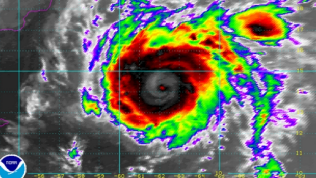
The Moderate Resolution Imaging Spectroradiometer or MODIS instrument aboard NASA’s Aqua satellite got a good look at the eye of Tropical Cyclone Chapala in the Arabian Sea on October 30 at 09:10 UTC (5:10 a.m. EDT).
Advertisement
Cyclone Chapala spins over the Arabian Sea, headed towards a landfall in Yemen or Oman.
Chapala is poised to strengthen to become a “super cyclonic storm” within the next 24 hours, packing wind speeds of between 220 and 230 kilometres (127-143 miles) per hour in the next 24 hours, it added.
Earlier this month, Hurricane Patricia intensified into the strongest tropical storm ever recorded in the western hemisphere in just a few days.
Regardless of its strength, Chapala has the potential to dump a year’s worth of rain or more in just a day or two over parts of eastern Yemen and southwest Oman, the Weather Chanel said. The system could produce close to 20 inches of rain in a few areas of the arid landscape, which usually only records about 4 inches of rain in an entire year, according to the U.K.’s Met Office, making flooding and mudslides a major concern.
Dry, desert air and low thermal energy will help to weaken Chapala as it nears shore.
As Cyclone Chapala approaches the Oman coastline, residents are being warned of rough seas and fresh winds in the UAE over the weekend, with a chance of rainfall in parts of the country. However, Cyclone Chapala may be intense enough to prohibit it from weakening below hurricane intensity, with winds of 74 miles per hour or greater, prior to making landfall.
Oman is preparing to face Cyclone Chapala, which now lies 850 km off the coast off Dhofar.
In May 1999, Cyclone ARB 01 slammed into Pakistan near Karachi as a strong Category 3 equivalent storm, killing at least 700 in Pakistan.
The storm was caused by high sea temperatures and atmospheric conditions, but it was not clear if it was also caused by the El Nino weather phenomenon or by global warming, and if such storms might recur in future, she said. This allowed Chapala to take advantage of the very warm ocean waters of the region and send its convection into overdrive. Storms of this kind that happen in the Indian Ocean (where the Arabian Sea is) are called cyclones; they’re called hurricanes in the Atlantic and Northeast Pacific and typhoons in the Northwest Pacific.
Advertisement
Chapala rapidly intensified and is estimated to have winds of Category 4 hurricane intensity and may reach Category 5 intensity soon.


