-
Tips for becoming a good boxer - November 6, 2020
-
7 expert tips for making your hens night a memorable one - November 6, 2020
-
5 reasons to host your Christmas party on a cruise boat - November 6, 2020
-
What to do when you’re charged with a crime - November 6, 2020
-
Should you get one or multiple dogs? Here’s all you need to know - November 3, 2020
-
A Guide: How to Build Your Very Own Magic Mirror - February 14, 2019
-
Our Top Inspirational Baseball Stars - November 24, 2018
-
Five Tech Tools That Will Help You Turn Your Blog into a Business - November 24, 2018
-
How to Indulge on Vacation without Expanding Your Waist - November 9, 2018
-
5 Strategies for Businesses to Appeal to Today’s Increasingly Mobile-Crazed Customers - November 9, 2018
Typhoon ‘Lando’ enters PAR
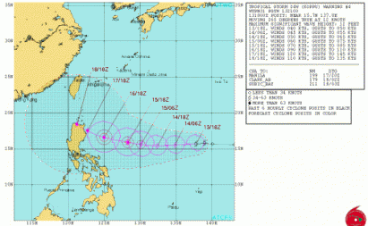
Now with the name “Lando”, the storm was spotted 1,440 kilometers east of Luzon at 2 pm on Wednesday, October 14, said the Philippine Atmospheric Geophysical and Astronomical Services Administration (PAGASA). The Joint Typhoon Warning Center’s forecast track for the storm has it making landfall in the northern Philippines over the weekend.
Advertisement
The Weather Underground categorizes the tropical storm to number 4, equivalent to super typhoon (210 kph to 250 kph), when it will pass through Northern Luzon on Sunday.
Koppu was moving to the west at 11 knots (12.6 mph/20.3 kph).
Duran, however, said tropical storm Champi (international name) is still too far to determine whether it will also enter the PAR.
Pagasa on Wednesday morning located Koppu 1,675 kilometers east of Luzon with maximum sustained winds of 65 kilometers per hour and gustiness of up to 80 kilometers per hour.
The Moderate Resolution Imaging Spectroradiometer or MODIS instrument that flies aboard NASA’s Terra satellite captured an image of Tropical Storm Koppu as it was strengthening from a depression on October 13.
Advertisement
She noted fair weather or partly cloudy to cloudy skies with isolated thunderstorms will prevail over Metro Manila and the rest of the country. Elsewhere, winds will be light to moderate coming from the northeast to northwest with slight to moderate seas.


