-
Tips for becoming a good boxer - November 6, 2020
-
7 expert tips for making your hens night a memorable one - November 6, 2020
-
5 reasons to host your Christmas party on a cruise boat - November 6, 2020
-
What to do when you’re charged with a crime - November 6, 2020
-
Should you get one or multiple dogs? Here’s all you need to know - November 3, 2020
-
A Guide: How to Build Your Very Own Magic Mirror - February 14, 2019
-
Our Top Inspirational Baseball Stars - November 24, 2018
-
Five Tech Tools That Will Help You Turn Your Blog into a Business - November 24, 2018
-
How to Indulge on Vacation without Expanding Your Waist - November 9, 2018
-
5 Strategies for Businesses to Appeal to Today’s Increasingly Mobile-Crazed Customers - November 9, 2018
Unorganized storm predicted to enter Gulf, but its path is uncertain
Previous reports said that the tropical disturbance may strengthen and become a full-blown storm.
Advertisement
Residents of Florida to Alabama, Mississippi and Louisiana were advised by forecasters to continue to monitor the progress of Invest 99L and spend time reviewing storm plans as a precaution.
Invest 99L is moving west through the Straits of Florida, according to the latest update from the National Hurricane Center.
The heaviest storms could bring damaging wind gusts, power cuts and rough seas, as well as the potential for a couple of tornadoes. Meanwhile some areas along the south and east reported strong rains Friday afternoon till evening.
More of a threat to the US mainland, but not to Florida, is Tropical Depression Eight that has formed in the Atlantic west of Bermuda, bringing the possibility of heavy rain to the coast of North Carolina early this week.
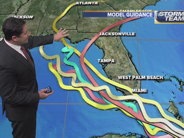
Forecasters have had difficulty predicting the disorganized storm’s path and it remains elusive as to where it will head after passing the Tampa Bay area. Heavy rain could still persist in the area leading to mudslides and flash flooding especially to some parts of the Caribbean, Hispaniola and central Cuba. Florida should expect rain which could continue till next week.
On this Saturday, the tropical disturbance (99L) is continuing to move to the west-northwest at about 10 miles per hour. The spaghetti plots show it could go anywhere in the northern Gulf – from the central Texas coast to south Florida. It showed little becoming of “99L” as it approached and moved near/just south of south Florida.
Advertisement
Most recently, a few days ago a tropical disturbance organized out of a wave that was supposed to possibly further develop into a tropical storm or a hurricane in the Big Bend area.


